Finding Wild Trout, Made Easy
I love all different kinds of fly fishing, from saltwater, to warm water, to competitions and everything in between. My favorite aspect of the sport, however, is exploring and finding wild trout streams. I devote the vast majority of my time to hunting wild fish around my college in Centre County. Over the past couple years, I have fished 109 different streams in Pa that hold wild fish, and my goal for this year is to fish another 50.
I think very few people get to realize the full potential of the areas they fish because they get stuck fishing the popular streams. I have one friend that fishes seven well known streams in Pa almost exclusively, despite knowing of and living near many others. He believes they are the only ones worth fishing, just because they get so much traffic. Obviously, these big name creeks are loved by so many for a reason, but believe me there are just as many sleeper streams as good or better. These streams may be written about in a book, hidden within the class A list, or never mentioned at all, which is why you have to do some searching.
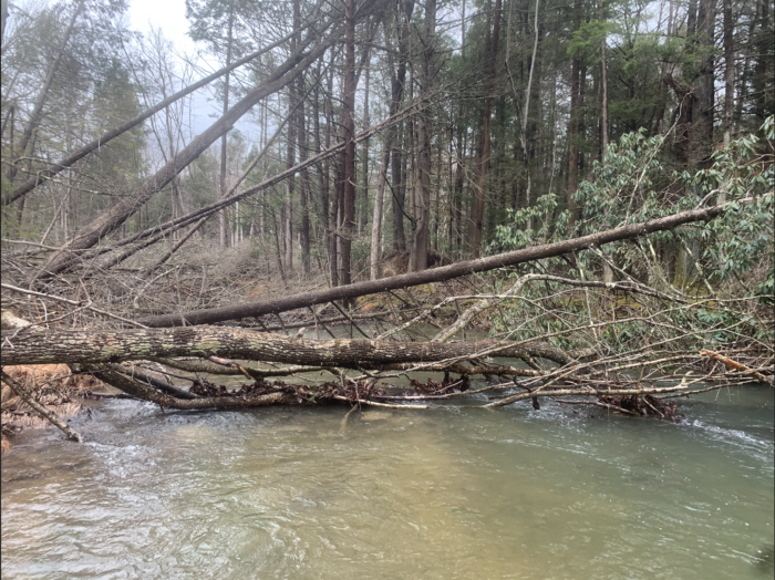
Wild trout live in more places than most people imagine. Of course you can find them in little known mountain streams, but they can also survive and even thrive in much less pristine areas. I’ve caught good fish in waterways that flow through cities and beside major highways. I have even found them in creeks stained orange by acid mine drainage. Once you know how to look, you can find them everywhere.
A lot of people think that finding productive streams is all leg work, consisting of putting in miles on foot and by car. Which is sort of true, once you find a stream you have to fish it hard. However, if you put in the time beforehand, you can save yourself from fishing subpar water. Luckily, doing stream recon has never been easier, with a ton of great and accessible mapping programs currently online. There’s a few specific ones that I think are super helpful and underused-
Gogal Publishing’s Stream Maps
This is by far the best map program for finding new streams. For some reason, few people use it or even know about it. It’s one of the only maps devoted to streams, with every waterway colored in a different color to distinguish them. You have the option between several different basemaps, including satellite, topographic, and road, which are the ones that I use most. The stream data is much more complete than anything you can find on google, and even most dedicated topo maps.
Each waterway is labeled with its given name, and you have the option to search for a stream’s location by name. You can also drop waypoints to mark streams that look promising, and get directions directly to your dropped point. The creators have linked the location and data from USGS gauges, so it’s available at the touch of a button. The app is available for download on IOS and Android, for $9.99 for each region. I love this app, it makes finding streams so much easier. I highly recommend checking it out, as it’s well worth the money.
OnX Hunting
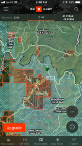
Hunters use OnX to make sure they don’t wander onto property they don’t have permission to hunt, and it works great for fishermen too. The app shows you the area you’re in overlaid with property lines. It makes it easy to identify if you are on private property, and lets you know who owns the property, and subsequently who to ask to hunt or fish. I find it really helpful that it can show small areas of public property that appear private, which saves me the trouble of asking the wrong people for permission.
It can also save you if you come across landowners who yell at you for fishing on “their property”, as you can pull it up and prove that the stream is public. I actually started using this app after I accidentally fished onto private property without realizing it, and had the landowner pull a gun on me. I never wanted that to happen again, so I try and play it safe now. It is a little expensive at $20 per year, but well worth it. If you want to go a cheaper route, property info is public online, but it takes longer to find and load.
Google maps and Google Earth
Google maps is likely the most popular mapping software out there. It’s less detailed than the above options, but great for getting you where you want to go and for a quick reference. Not to mention its great for finding the closest sheetz when the post-trout munchies kick in. It’s not an extraordinary help for finding streams but it comes with most phones, and it’s free to download. If you have an iPhone, apple maps works just as well.
Google earth is one a lot of people overlook nowadays. It is NOT the same as satellite view on Maps. Google Earth has much higher quality satellite imagery that makes getting a good look at target streams easy. It’s amazing how close of a view you can get with this. Like Maps, it’s also free to use online or download.
These tools make finding good, accessible trout streams more of a straightforward process than a game of chance. Don’t get me wrong, there’s always a time for good old paper topo, especially on backroads where cell reception is spotty, but we have a lot more powerful options these days. No matter what type of map you use, there are a few tricks to narrow down the search. I have a two step process that I follow to find trout in new areas. It’s simple, but requires some thought and time input to do right.
First, start with what you know. It’s nearly impossible to find new wild trout streams on the map in an area where you know absolutely nothing about the trout scene. You need to start by gathering reference points of known wild trout streams to extrapolate from. You can always find some with a simple online search and the states class A trout stream list. If your smart about it, old reference books, stories from other anglers, and social media can give away some sneaky, less known streams as well. Plot all these on a map along with any others you know from personal experience and your off to a good start. Not only are all these streams good spots to check out by themselves, plotting them goes a long way to finding more to fish.
Second, look for clusters. Once you have a map with all your points on it, you can start to see patterns. Some places, for one reason or another, are just prone to have more wild trout streams than others. You can infer that streams around these places are more likely to have wild trout as well.
There are three features that indicate that a stream may have an extra high chance of having fish- streams that flow off the same mountain as other productive streams, streams that are tributaries to productive streams, and streams that have productive tributaries. If a creek has one or more of these features, it’s worth a look. That’s not to say that a stream with none of those features can’t hold wild fish, as many do, it’s just less likely. Let’s look at these features case by case, starting with streams that flow off the same mountain.
In a mapping class I took at Penn State, we were told the first law of geography is that everything on the map is related, but close things are always more related than far things. This holds true for trout streams. If you look on the map and see that the headwaters of a stream begin near (within 10 or so miles) a stream with a known wild trout population, I’d say there’s a 6 out of 10 chance it holds wild fish. This is because the geological features that allow fish to reproduce in one stream very likely extend to the other. Barring any damage done by people, streams in this close proximity will have similar substrate makeup for spawning, will likely be connected to the same aquifer, and have similar PH values.
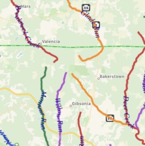
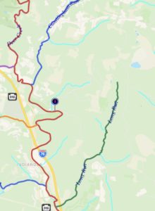
Here is an area where four streams originate from the same area. Though they are part of different drainages, if one of these streams has wild reproduction, the others likely will as well
Tributaries to wild trout streams are prime candidates for wild trout. Not only do they usually meet the first case and have geological similarity to the stream they flow into, but they have the added benefit of usually being colder and cleaner. Tributaries are more secluded and tree covered, keeping them cooler over their length. They flow over much less area and have less water input, which makes them much less likely to be affected by sedimentation and pollution.
The larger streams that they feed pick of nasty things along their course, and are warmed as they flow away from the seeps that create them. These issues in water quality are usually magnified the further downstream you go. So, if a river is good enough quality to hold wild fish, you can bet that many of its tributaries are as well. Tributaries can also provide a refuge in the summer. If the main stem gets too warm for fish, they move to the cooler tributaries, which can make for some epic summer fishing. For these reasons tributaries to wild streams are your best bet to find more wild fish.
If a stream like deer creek has wild fish, a tributary like long run will most of the time as well.
Lastly, you have streams with productive tributaries. These are the least likely features to have wild fish, however when they do, the fish are usually bigger. These streams suffer from the magnified water quality issues described above, and the bigger and longer the stream the more pronounced these issues are. Large streams have a lesser overall quality, but more food and space for fish to grow. For these reasons streams with productive tributaries usually have lower fish density and a larger average fish size.
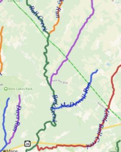
If all of these tributaries to Bull creek contain wild trout, there’s bound to be a few in Bull creek too.
None of these are hard and fast rules, just observations I’ve made that I find generally hold true. I know of one stream near my home in Pittsburgh that has decent numbers of wild browns even though absolutely no other stream for miles has fish. On the flip side, I have fished streams in central Pa that flow off the same mountain as some of the best creeks in the world and just don’t hold wild trout. I won’t say that this method will turn up every good stream, but I can guarantee that it will yield a lot of positive results. If you have any questions, feel free to drop a comment or send me a message. I also have open dates for trips left all throughout the summer, which you can book here if you want to really learn some some good stuff. Tight lines everyone, and get out and explore in this great weather!